Satellite Imaging Software: 5 Best to Use in 2026
Key notes
- The best satellite image software will help you see the world from above with great accuracy.
- Unquestionably, the most famous and accessible tool is the one provided by Google.
- A great solution from Maptitude allows you to use aerial imagery to create excellent maps.
- You can also install a complex tool from NASA that is open-source and offers great features.

There are lots of websites from all kinds of agencies all over the world that equip you with high-quality satellite imagery of all sorts of places from our planet.
There are both free and paid software that provide satellite data, and we gathered five of the best sources.
Just take a look at our top picks and after you check out these tools’ sets of features decide for yourself which one is the best choice of eyes from the sky that you would like to use.
What are the best satellite imagery tools for your PC?
Google Earth
We beat that everyone has heard about Google Earth and it’s excellent that recently it has been redesigned in order to offer users a better overall experience.
Google Earth was designed to offer a beautiful and user-friendly experience.
Check out more features and functionalities that come with this fantastic program and get Google Earth from the official website to give it a try for yourself.
There, you will find Google Earth for Chrome and older versions as well. In case you encounter any issues while using Google Earth on PC, this troubleshooting guide will help you fix them in no time.
Take a look at the most impressive features that are packed in this popular software below:
- You will be able to discover new content and visualize 3D imagery of cities and more places on Earth
- You will have access to Street View imagery, and you will be able to share links to specific Street Views
- The speed that you can move around with is enhanced, and the program’s performance is comparable to the Classic GE
- There a feature called Feeling lucky? that will randomly fly you to an exciting place on Earth to provide you data about it
- The Voyager is a brand-new way to explore lots of content with extensive information available
- You will be able to experience interactive stories from all over the world in Voyager
Maptitude Mapping Software
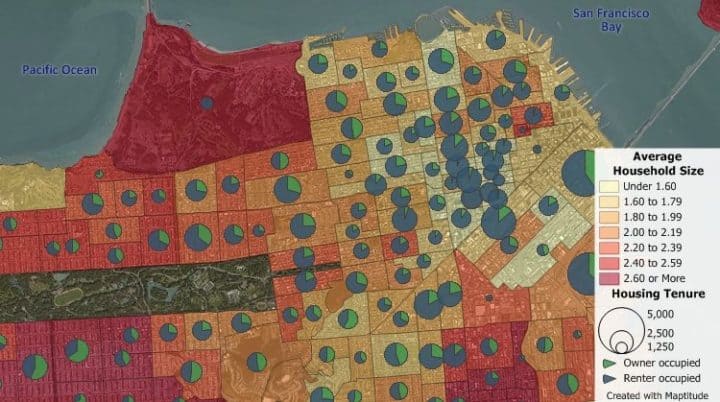
Maptitude Mapping Software is another excellent satellite imagery program. The pictures and images enhance the maps and expand the type of data that you are able to use.
This software allows you to use one or more photos, satellite images, aerial photographs, and scanned docs as layers to create maps.
Maptitude Mapping Software offers you a few OpenGIS web Map Services by default, and you will also get full control over which servers are listed.
If you have installed at least version 4.0 of Google Earth and later versions and you have access to the Internet, you will be able to use the Google Earth toolbox as well.
Check out more exciting functionalities and features that are included in this program:
- The features included in Maptitude Mapping Software can improve the appearance of your maps
- You will be able to add more information to your maps
- The program provides a basis for editing and updating your map files as well
- Using this software, you will be able to access free imagery from the Internet for various locations in the world
- Maptitude Web Map offers you access to satellite and imagery from all kinds of Internet sources
- The tool automatically updates the image resolution and location
- There’s also the WMS Image toolbox included, and this lets you download aerial photos, maps, and more effortlessly
- You will be able to enjoy the Google Earth toolbox as well which will let you use Google Earth images for your maps
- Using this program, you will be able to download imagery from anywhere on Earth with a single click of a button
Worldview from NASA Software
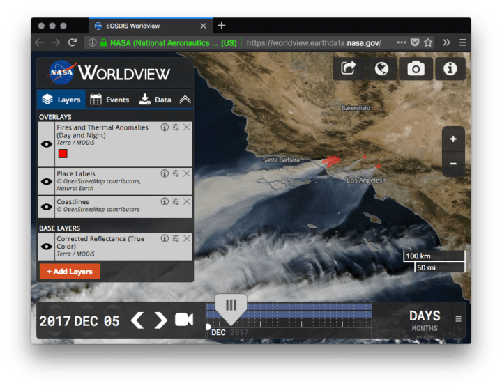
Worldview is a satellite imagery browsing and downloading tool that comes packed with awe-inspiring features.
With Worldview, you will be able to pan and zoom quickly through space and time in order to find the most cloud-free and relevant data that is currently available.
Check out the best ones below:
- This tool is designed for interactive browsing and downloading imagery from NASA’s own Earth-observing satellites
- The software is building upon a set of open-source mapping and user interface libraries
- Worldview provides an environment to visually discover really interesting phenomena just as it is observed by NASA’s satellites
- You will get the chance to download the data for further analysis
- This program was initially designed in order to offer relevant data for time-critical scenarios such as flood and wildfire management
- Satellite imagery is now available in this program to view it within four hours of observation
- You will be able to view the imagery in the highest and the native resolution
TerrSet
TerrSet is a Geospatial Monitoring and Modeling Software. This is an integrated geospatial system for monitoring and modeling the Earth system for sustainable development.
You can check out the complete features that are included in this amazing tool on the TerrSet official website.
Take a look at the most important features that are packed in TerrSet:
- It incorporates the IDRISI GIS Analysis and IDRISI Image Processing tools along with a vast constellation of apps
- You will get the most extensive set of geospatial tools in just one package
- You will not need to buy all kinds of expensive add-ons in order to extend your search capabilities
- The IDRISI GIS tool provides more than 300 analytical tools for manipulating the geospatial datasets for the exploration of our world
- You will be able to use a vast set of procedures for image restoration, transformation, enhancement, and classification of remotely sensed imagery
- The Habitat and Biodiversity Modeler is a vertical app targeted at habitat assessment, biodiversity modeling, and landscape pattern analysis
- This software comes with a tool called GoOSIRIS that is able to quantify and map the impact of national-level REDD projects on carbon emissions, deforestation, agricultural revenue, and carbon payments as well
- The Ecosystem Services Modeler is a support system that will access the value of natural capital for sustainable development
- The software also includes an Earth Trends Modeler which is a set of tools for analyzing image time-series data associated with Earth Observation remotely sensed imagery
- There’s also a Climate Change Adaptation Modeler that includes a set of tools for modeling climate and assessing its impact on sea level rise, species distribution and crop suitability
Geomatica

Geomatica is another excellent satellite imagery tool that comes with an extensive set of features and functionalities.
Overall, Geomatica offers user everything they need for accurate and fast results. The image thumbnails and the background reference layers make the project set up effortless.
There are lots of efficient editing tools included, and the image deactivation functionality and detailed reporting feature allow you to get a flawless job quickly.
More features are worth checking out, so it’s best to head over to Geomatica’s official website and take a look at all of them there.
You can check out the best features below:
- This is an easy-to-learn and effortless to use software with Object Analyst add-on that guides you through image segmentation, feature extraction, and training site creation
- By segmenting images into discrete shapes, relationships, and boundaries, it can be easier to see and analyze data
- With this software, you will be able to shape manipulation and accuracy, and this will allow quick image processing and results as well
- Geomatica comes with an automatic GCP feature and tie-point collection
- You will also be able to use a multi-way point selection, and you can calculate relative, absolute, and combined models
These are five of the best tools that provide satellite imagery, and we recommend that you pay a visit to each official website to check out their complete sets of features before you make your final decision.
You might also be interested in one of the best Windows 10 maps apps to use on your PC and find your landmarks.
Did you use one of the tools above? Tell us more about your experience in a comment from the se
Read our disclosure page to find out how can you help Windows Report sustain the editorial team. Read more


Improve this guide


User forum
0 messages