Road Design Software: 4 Best to Use in 2026
Create road designs efficiently with any tools from here
Key notes
- For accurate design of highway projects you need the best road design software for PC.
- One of the software below offers seamless design management and dynamic terrain handling.
- Another tool offers automatic design regeneration delay for efficient road centerline modification.
- We also provide you with a dedicated civil infrastructure application with numerous features.

The best software for road design includes a plethora of functions that help to dramatically cut the time it takes to design roads. Even demanding design elements like cul-de-sacs and intersections are automatically created making the whole process super-fast.
In addition, the best software for highway design leads to precise designs and contributes to a smooth process from conceptualization through construction.
How road design software works
Road design software is equipped with a collection of features that automate every step in the design.
Data collection, contouring, terrain modeling, site design, and earthwork quantities are all done automatically. Culverts and corridors design, drainage layers, walls and guardrails, roundabouts, alignments – everything is done fast.
Your role is just to feed the details and let the computer take over. Most will also allow customization to better capture the complexities involved in taxing projects.
Importantly, the road designer is given complete control over relevant design data and has constant access to project information.
Types of road design software
The software varies in design framework with some being 2D and a majority offering interactive 3D.
Other differences can be seen in capabilities, customization, and even in how the software is availed (cloud-based or via downloads).
Some of the software is open-source (and free) while a good number are subject to commercial licenses.
Having said that, engineers will find a solution to meet their needs whether working on a simple rural road project or a mega superhighway.
Here are our nominations for the best software for road design.
What’s the best highway design software for Windows 10?
Autodesk AutoCAD – 3D models for professionals
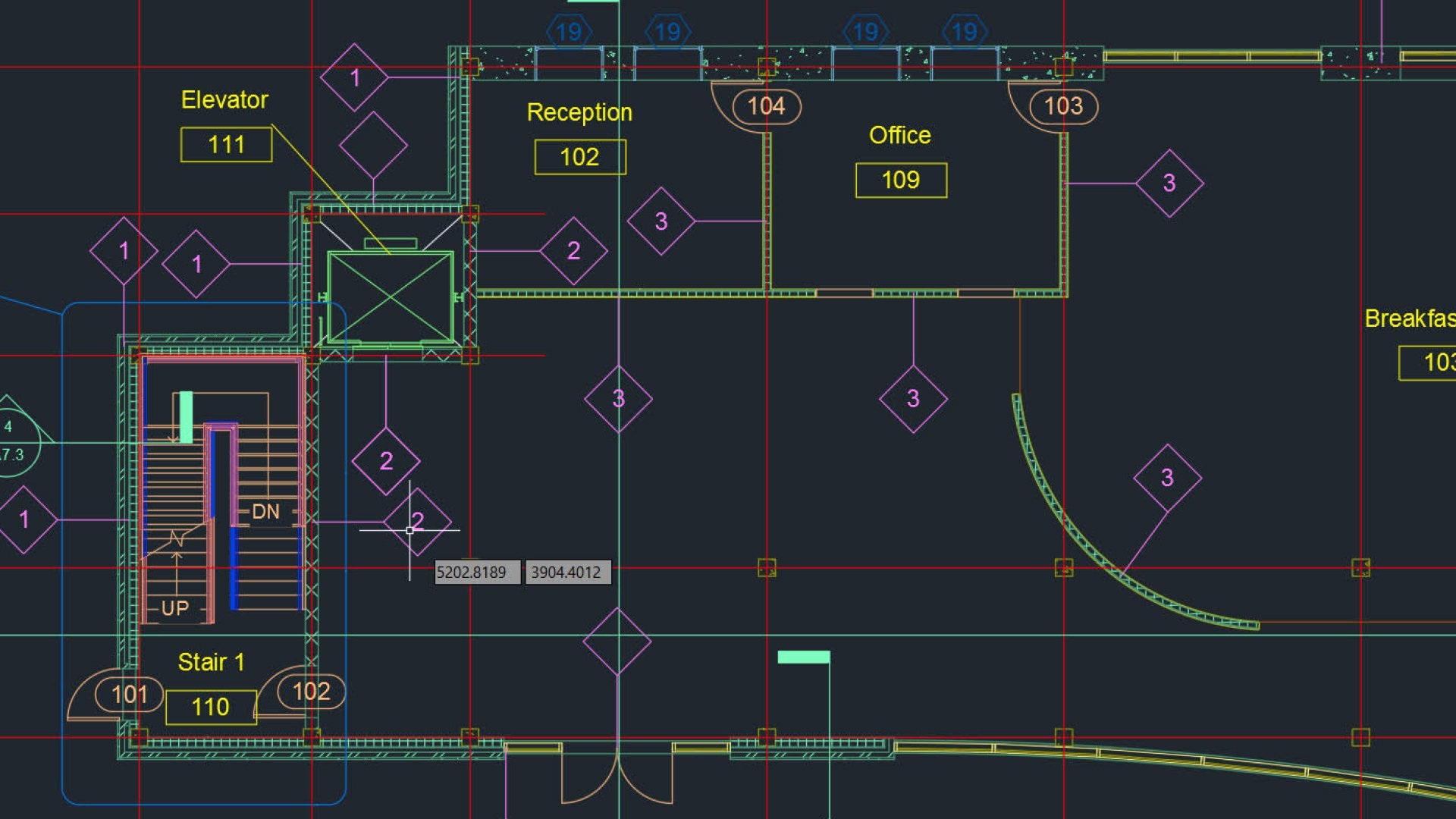
This solution is for the best CAD software in order to draw and design any road or object construction.
Firstly, it has a friendly UI that allows designers to create and edit their designs efficiently. Not only that, you can use it to draw and create 3D models for your construction.
More exactly, you can get various editing tools such as lines, shapes, text, and dimensions for your final project to succeed.
In addition, it gives you extensive customization options to tailor the software according to your project specific and goals.
You should also be aware that it’s possible create macros and automate repetitive tasks to streamline the process.
Finally, you should confidently use this solution for the best automatic design and engineering service.

Autodesk AutoCAD
Create realistic road projects with this automated CAD solution.Autodesk AEC Collection – Total construction tool

This collection is a feature-rich design software designed by the reputable Autodesk development team.
It proves that Autodesk never sleeps and keeps on implementing new features to improve visualization and road design workflows.
From calculating materials quantities within specified areas of interest (AOI) to modeling parametric tunnels to making precise edits for profiles, and even to enhanced terrain contour views, InfraWorks works like a charm.
The program also offers rare qualities such as seamless design management, delaying automatic design regeneration for efficient road centerline modification, and dynamic terrain manipulation.
Well, it has a steep learning curve but with Autodesk publishing tons of interactive tutorials and videos, you should soon find your way no matter the sophistication of the project at hand.
If you’re passionate about delivering more accurate road designs, stunning 3D visualization, and excellent collaboration, InfraWorks 360 could be the way to go.
Autodesk AEC Collection
An all-in-one collection of professional programs to get your most ambitious projects.Civil 3D by Autodesk – Accelerated design automation

Yet another construction design software from Autodesk, this time one dedicated to civil infrastructure.
In terms of roads and bridge design, Civil 3D helps with the project design, but also with the necessary documentation.
Using 3D modeling options, you can create driving corridors, highways, 3-way or 4-way intersections, roundabouts, or drainage systems.
The flexible and visually dynamic features of the program allow you to efficiently plan according to field-captured data or with the already existing infrastructure.
Civil 3D eases your work thanks to the design automation options so that scripts can be reused and reloaded with repetitive data.
Of course, Civil 3D keeps all your project data stored in one single console that can be accessed from various locations or devices.

Civil 3D
Flexible and efficient workflows for civil engineering and documentation software to take your road and bridge planning one step further.Autodesk Revit LT – 3D BIM software

Our last recommendation, again developed by Autodesk, is Revit LT, a program that used Building Information Modelling technology to produce high-quality architectural designs and documentation.
It’s a simpler software compared to the all-in-one packages presented before, that includes only automated BIM workflows aiming to improve project quality and overall design process.
It also helps with project management challenges by keeping all data in one place and neatly aligned with the schedule.
You can share your Revit LT designs with other users of AutoCAD or Revit, and get feedback to see where you stand with your skills and ideas.

Revit LT
Deliver professional 3D designs using Revit’s automated workflows and stay on track with your road planning projects.If you’ve already tried one of these tools or if you know of another one worth mentioning, use the comments section to tell us more.
Read our disclosure page to find out how can you help Windows Report sustain the editorial team. Read more


Improve this guide

User forum
0 messages