Drone Mapping Software Free to Download
What are the best free drone mapping software solutions?
WebODM
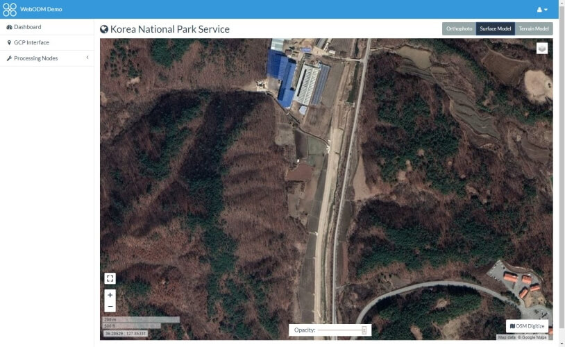
The ODM in WebODM stands for “Open Drone Mapping,” so you might’ve figured out that this software solution is the open-source one we’ve been talking about in the intro.
The software was released in 2017, but it has gathered a whole lot of followers, as the community behind the project continued to help it evolve.
This tool can help you perform a lot of awesome operations with your drone, such as generating orthomosaic maps, point clouds, contour maps, digital elevation models (DEMs), and even 3D models from aerial images.
WebODM is plenty generous when it comes to the amount of features it encompasses, but there’s a catch. This tool comes in two flavors: manual install and auto-installer.
However, the auto-installer costs quite a lot (compared to paying nothing for the tool, that is), but if you’re not afraid of getting your hands dirty, you can grab the source code and follow the instructions to build the tool.
Pix4Dmapper
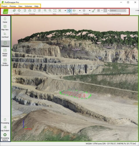
Pix4Dmapper is a specialized software solution that allows you to create professional 3D maps and models from images, by turning them into geo-referenced 2D or 3D maps and models, depending on your needs.
You can customize the 3D maps, and even import them in other programs if you want to.
This tool makes use of images to create point clouds, terrain models, textured models, orthomosaic maps, but also capture thermal, multispectral or RGB images with any camera.
The free, complementary Pix4Dcapture app can help you automate both the flight of your drone and its image data transfer.
Pix4Dmapper can be tried for free, but the trial period is unfortunately only 15 days long. It’s possible to use this tool from your desktop computer or the cloud, according to your preferences.
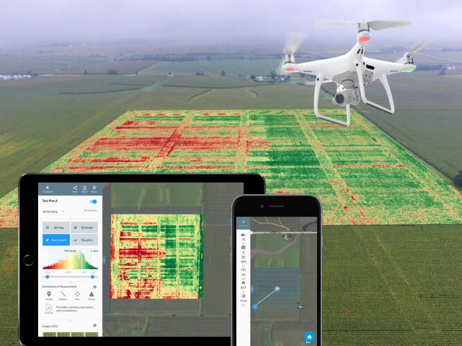
DroneMapper RAPID
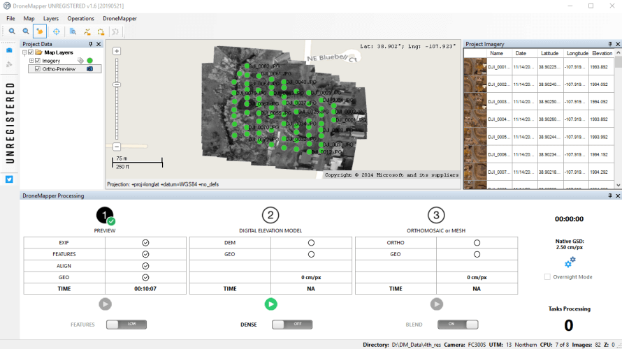
DroneMapper RAPID is not entirely free, but you can download it and try to see if it suits your needs well before making the commitment of purchasing a yearly license plan.
The not-so-bright side is that the limited version of this tool can only produce a review, as seen in the screenshot above.
DroneMapper RAPID can help you create high-resolution DEMs (Digital Elevation Models) and orthomosaics, and it can use up to 250 geo-tagged JPEG images of at least 12 Mpixels for a single project.
After feeding it the images it requires, this tool can create a preview, an orthomosaic scaled at either X2, X4 or native resolution, and a DEM scaled at X2, X4, X8 or native resolution as GeoTiff files.
Note that this tool uses ground control points to process its content, so before feeding it the images you want to use for your projects, you must pre-process them with the included GCP TOOL.
DJI TERRA
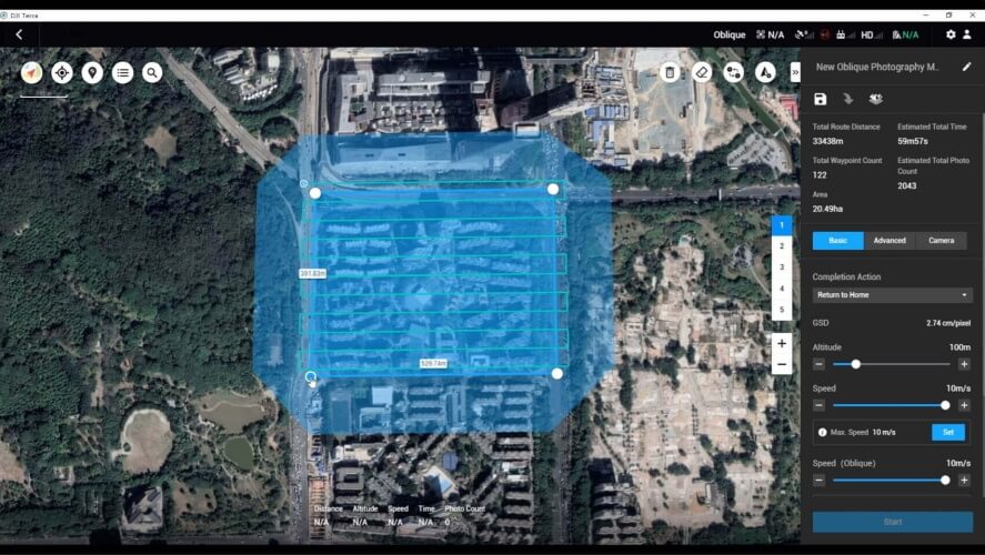
As its name clearly states, DJI TERRA was developed by one of the most popular drone producers, DJI, and it delivers a professional environment to perform captures, analyze them and transforming real-world scenarios into digital assets.
This tool offers three different planning types, depending on the project you’re working on:
- Area – captures the specified area by drawing a flight zone on a map, which DJI TERRA generates automatic flight path options based upon;
- Waypoint – lets you create dynamic, custom flight paths using waypoints, as well as customizable parameters such as speed, altitude, or angle;
- Oblique – the drone captures an extensive set of data by flying on the same route multiple times, automatically;
It goes without saying that this tool alone can’t do much if it’s not paired with a competent drone, to begin with. Currently, it can only be used with a Phantom 4 Series drone that supports DJI TERRA.
A laptop, a microSD card, a card reader, a compatible cable, as well as several batteries are also needed to use this tool the way it was intended.
DroneDeploy
DroneDeploy may be the last entry on our best free drone mapping software list, but that doesn’t mean it’s less competent than its competitors. However, there is a good reason why we’ve placed it last, and that’s because you can’t have it on your Windows computer.
Sorry, but if you were planning on using DroneDeploy, you’ll have to do so on your Android or iOS device.
This tool can help you automate flights for your drone and capture imagery at the same time, making it a versatile solution for drone users who are interested in performing aerial mappings the way they should be done: fast and without too much hassle.
What makes DroneDeploy really stand out in the crowd is its wide support for drones. Basically, you can feed it geotagged images from any drone and it will use it to create a high-resolution map for you, as well as reports, 3D models, and even real-time 2D live maps on the side.
You can try DroneDeploy for free for 14 days, but after that, your experience will be limited by the maximum number of maps you can process and the lack of some advanced features (e.g. data exports, volumetric calculations).
Bottom line on best free drone mapping software
To sum it up nice and tidy, technology has reached the point where tasks that were usually handled by heavy machines such as manned aircrafts can be carried out by small (in comparison), silent drones and a laptop. Aerial mapping using a drone is way less expensive and far more convenient.
However, no drone can be as effective as it can without proper help from specialized software. Therefore, if you’re set on performing some serious aerial mapping for yourself, you might consider using tools like DJI TERRA, WebODM, DroneMapper RAPID, or DroneDeploy.
Read our disclosure page to find out how can you help Windows Report sustain the editorial team. Read more


Improve this guide


User forum
0 messages